


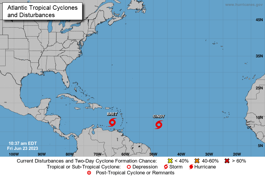


(CMR) Tropical Storm Cindy has formed behind Tropical Storm Bret, the first case of two storms in the tropical Atlantic in June, as Tropical Storm Bret remains active in the Caribbean.
Some forecasters blamed unusually high sea temperatures for the rare development.
“The Atlantic is awfully warm this year,” Kerry Emanuel, a meteorologist at the Massachusetts Institute of Technology, told ABC News, adding that it's partly a result of global warming, natural variability, and the ocean's recovery from sulfate aerosols pollution that cooled it decades ago.
Studies show that a warmer world is producing wetter and more intense hurricanes, with scientists still trying to figure out if climate change alters how many storms brew. Because of more early and pre-season storms, the National Hurricane Center has started issuing advisories earlier in the year, with experts recently discussing the idea of declaring the start of the hurricane season earlier.
According to the National Hurricane Center 11 am bulletin, the center of Tropical Storm Cindy was located near latitude 12.5 North, longitude 48.0 West. Cindy is moving toward the west-northwest near 16 mph (26 km/h), and this general motion is expected to continue over the next few days. On the forecast track, the system is expected to remain well east and northeast of the northern Leeward Islands through early next week.
Maximum sustained winds have increased to near 50 mph (85 km/h) with higher gusts. Some additional strengthening is forecast over the next day or so followed by gradual weakening afterwards. Tropical-storm-force winds extend outward up to 60 miles (95 km) from the center.
Meanwhile, Tropical Storm Bret was moving at 18 mph about 370 miles east-northeast of Curacao, with maximum sustained winds of 60 mph.
Tropical storm warnings were in effect for St. Vincent and the Grenadines due to Bret's movements. The storm is expected to weaken during the next two days and dissipate by early next week.
- Fascinated
- Happy
- Sad
- Angry
- Bored
- Afraid


