


(CMR) Hurricane Dorian is now a Category 4 hurricane as it heads towards Florida this Labor Day weekend.
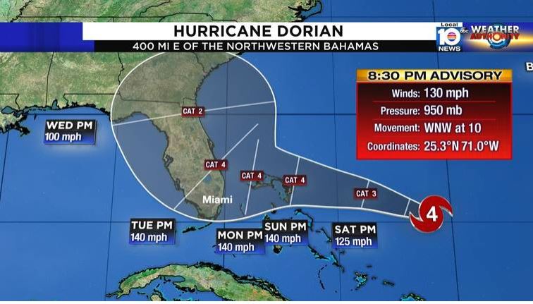
In the 8:30 p.m. advisory, Dorian has winds of 130 miles per hour and is moving west-northwest at 10 mph. Residents are encouraged to finalize their preparations ahead of the storm.
Hurricane Dorian is reorganizing temporarily, but significant intensification is still expected to continue soon. It's currently about 800 miles from Miami.
The northwestern Bahamas will be impacted first by Dorian with hurricane watches being issued this evening. The Hurricane Hunters flew through Dorian, and have found maximum sustained winds have climbed to 130 mph, making Dorian a Category 4 hurricane.
Pressure has also dropped down to 950 mb, which is a 20 mb drop from the 5pm advisory. The drop in pressure may be the beginning of a rapid intensification phase.
The forecast is fairly straightforward for the next couple of days. The storm is very likely to move northwest until it bumps into a strong, blocking high-pressure area. That high will deflect it to the west in the direction of Florida. In addition, Dorian will grow in size on its trek west.
There are no obvious large-scale impediments in Dorian's path. Upper-level winds are generally favorable for strengthening and the ocean water is very warm, especially when it gets near Florida.
The computer forecast models and the official National Hurricane Center forecast show Hurricane Dorian slowing down significantly as the approaches Florida.
The afternoon models still show a wide range of possibilities for the evolution of the weather pattern over Florida, and how it will steer the hurricane. The main take-away is that the hurricane is expected to move very slowly when it gets to the vicinity of Florida.
This slow movement has a lot of bad ramifications: Storm surge at the coast and in bays and rivers will be higher because the storm has more time to pile up water.
This on top of the King Tides, which already are a foot or more higher than normal water levels. In addition, the flooding threat from heavy rain is drastically enhanced, as with Hurricane Florence last year. About a foot of rain is the current forecast, but that is subject to change.
There is high confidence that Dorian is going to eventually turn to the north. The unknown is where that turn will take place. The National Center Forecast shows the turn happening over or very near the Florida peninsula in South Florida.
- Fascinated
- Happy
- Sad
- Angry
- Bored
- Afraid


